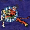
Air Transport Command | ATC, North African Division and novelty nude issues
By
walika,
in WALIKA'S WWII ARMY AIR FORCES RELATED PATCHES
By
walika,
in WALIKA'S WWII ARMY AIR FORCES RELATED PATCHES
Recommended Posts
Create an account or sign in to comment
You need to be a member in order to leave a comment
Create an account
Sign up for a new account in our community. It's easy!
Register a new accountSign in
Already have an account? Sign in here.
Sign In Now